Explore the Growing List of AAG 2017 Field Trips, Workshops and Excursions
Explore the rich physical and cultural geography of Boston, Mass., and the New England region through informative field trips led by geographers or other experts. Field trips and excursions are also an excellent way to meet and exchange ideas with colleagues and friends. Also, expand your knowledge base and sign up for a workshop within your area of expertise.
Attend Special Sessions on the 2016 U.S. Elections: Implications for Geography and Beyond
The 2016 elections in the United States may impact geography and our nation in the years ahead in many ways. Every year, the AAG addresses “late-breaking” events through special sessions at our Annual Meetings. During our upcoming 2017 AAG Annual Meeting in Boston, the AAG will hold a series of sessions within the special track, The 2016 U.S. Elections: Implications for Geography and Beyond, focused on analysis and research on the 2016 election, and what the results may mean for geography, the nation, and our planet.
This special track features the session, “The 2016 U.S. Elections: Implications for Geography and Beyond,” a high-profile panel session, chaired and organized by AAG President Glen M. MacDonald, with panelists Sarah Witham Bednarz, Texas A&M University; Alexander B. Murphy, University of Oregon; Douglas Richardson, American Association of Geographers; Derek H. Alderman, University of Tennessee; Victoria A. Lawson, University of Washington; Julie Winkler, Michigan State University, among others. This special session will be held on Saturday, April 8, 2017, from 5:20 p.m. – 7:00 p.m. in Room 312 of the Hynes Convention Center in Boston.
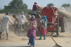
AAG Theme: Geographies of Bread and Water in the 21st Century
Burgeoning global population along with increasing appetite for high-protein or resource demanding food choices may double demands on world agriculture by 2050. At the same time groundwater depletion and climate change are negatively impacting the availability of sufficient water to meet agricultural and domestic freshwater demands in many regions. Compounding these challenges are socioeconomic forces, including armed conflicts and state collapse that negatively affect agricultural productivity, food transference and water resources. The challenges to food and water security over the 21st century represent an increasing and potentially existential threat to global society. These issues are fundamentally geographical in nature and form a central research and educational focus of geography and the AAG special theme.
The AAG Opening Presidential Plenary: Bread and Water in the 21st Century will anchor this featured theme. Speakers in this opening plenary session will be AAG President Glen M. MacDonald (UCLA), Ruth DeFries (Columbia University) and Peter Gleick (Pacific Institute). Discussants will be Laura-Anne Minkoff-Zern (Syracuse University) and William G. Moseley (Macalaster College).
Other special events related to this theme will include:
Physical Geography Poster Sessions: Check out hundreds of posters featuring research in physical geography. Session I is on Friday, April 7, from 1:20 p.m. – 5:00 p.m. Session II is on Saturday, April 8th, from 8:00 a.m. – 11:40 a.m. Note that the Physical Geography Reception/Happy Hour will take place during the latter half of Poster Session I, on Friday, April 7, from 3:00 p.m. – 5:00 p.m in the same area (Second Floor of the Hynes Convention Center, Hall C).
To find many additional sessions on this featured theme, consult the AAG website for a full list.
Share
Annual Meeting
AAG Theme: Mainstreaming Human Rights in Geography and the AAG
The special theme, Mainstreaming Human Rights in Geography and the AAG, will feature 50 sessions with more than 250 presentations at the intersection of human rights and geography within the 2017 AAG Annual Meeting and will build on the AAG’s decade-long initiatives in this area. Speakers from leading international human rights organizations, academia, government, and NGOs will address human rights challenges around the world.
Featured speakers above: Noam Chomsky, Audrey Kobayashi, Doug Richardson, Jessica Wyndham, Tawanda Mutasah, Sheryl Luzzadder-Beach, James Hansen and Colette Pichon Battle
The keynote plenary, “A Continuing Conversation with Noam Chomsky,” will kick off the Mainstreaming Human Rights in Geography and the AAG theme. Chomsky will engage in a conversational interview with AAG Executive Director Doug Richardson, as he has several times previously. The audience will also have an opportunity to ask questions following the interview. In addition, Chomsky will receive the 2017 AAG Atlas Award, the association’s highest honor. Be sure and add to your calendar this important keynote session scheduled for Thursday, April 6, 2017, from 5:20 p.m. – 7:00 p.m. in Ballroom B of the Hynes Convention Center.
Don’t miss another high-profile Human Rights session, “International Human Rights Priorities: Featured Perspectives,” with panelists Michael Posner, NYU Stern Center for Business and Human Rights and former Assistant Secretary of State for the Bureau of Democracy, Human Rights and Labor at the State Department; Terry Rockefeller, Board of Directors, Amnesty International USA; Beth Simmons, Andrea Mitchell University Professor of Law and Political Science, University of Pennsylvania; Jessica Wyndham, AAAS Scientific Responsibility, Human Rights and Law Program; Tawanda Mutasah, Amnesty International and Douglas Richardson, Executive Director, American Association of Geographers. This session is scheduled on Saturday, April 8, 2017, from 1:20 p.m. – 3:00 p.m. in Room 103, on the Plaza level of the Hynes Convention Center.
Additional special sessions will include the following notable speakers involved in various aspects of human rights:
James Hanson, known for his climate research and his Congressional testimony on climate change that raised awareness of global warming, will deliver a featured talk, moderated by AAG President Glen MacDonald, on Friday, April 7, from 10:00 a.m. – 11:40 a.m. in Room 210 at the Hynes Convention Center.
David Harvey, one of the most influential figures in geography and urban studies, and among the most cited intellectuals of all time across the humanities and social sciences, will deliver a featured lecture, “Marx, Capital and the Madness of Economic Reason,” on Saturday, April 8, from 3:20 p.m. – 5:00 p.m. in Ballroom B at the Hynes Convention Center.
Rush Holt, chief executive officer of the American Association for the Advancement of Science (AAAS), will deliver a featured talk entitled, “Advancing Science in the Public Arena,” on Thursday, April 6, from 11:50 a.m. – 1:10 p.m. in Room 103 of the Hynes Convention Center.
To find many additional sessions on this featured theme, consult the AAG website for a full list.
Share
Annual Meeting
AAG Theme: Uncertainty and Context in Geography and GIScience
Uncertainty and context pose fundamental challenges in geographic research and GIScience. Geospatial data are imbued with error (e.g., measurement and sampling error), and understanding of the effects of contextual influences on human behavior and experience are often obfuscated by various types of uncertainty (e.g., contextual uncertainties, algorithmic uncertainties, and uncertainty arising from different spatial scales and zonal schemes). Identifying the “true causally relevant” spatial and temporal contexts that influence people’s behavior and experience is thus also challenging, since people move around in their daily lives and over their life courses and experience the influences of many different contexts. To generate reliable geographic knowledge, these uncertainties and contextual issues will be addressed within the special theme, Uncertainty and Context in Geography and GIScience: Advances in Theory, Methods, and Practice, during the 2017 AAG Annual Meeting in Boston.
The Opening plenary of the Uncertainty and Context theme features a distinguished group of researchers and scholars experienced in addressing the issue of uncertainty. Speakers in this session include Mei-Po Kwan (University of Illinois at Urbana-Champaign) and Michael Goodchild (University of California). David Berrigan (National Cancer Institute) will serve as a Discussant and Tim Schwanen (University of Oxford) will chair this session. This plenary session is on Thursday, April 6, from 10:00 a.m. – 11:40 a.m. in the Independence West room at the Sheraton.
The Closing plenary for this special track will be held on Saturday, April 8, from 11:50 a.m. – 1:10 p.m and features Mei-Po Kwan (University of Illinois at Urbana- Champaign); Tim Schwanen (University of Oxford); Wenzhong Shi (The Hong Kong Polytechnic University); Jamie Pearce (University of Edinburgh); Daniel A. Griffith (University of Texas at Dallas). All attendees are welcome to attend.
To find many additional sessions on this featured theme, consult the AAG website for a full list.
Share
Post
NAACP Endorses AAG Letter Opposing Restrictions on Geospatial and Racial Disparities Data
NAACP and 26 other prominent national organizations signed on to a letter written by the AAG expressing concerns about proposed bills (Senate Bill 103 and House Bill 482) that could impose restrictions on the use of and access to geospatial data related to racial disparities. Read more about AAG policy action.
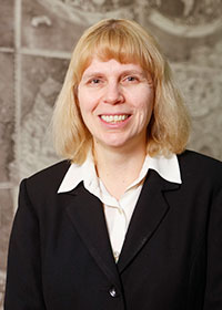
Paulette Marie Hasier Named LOC Chief of Geography & Map Division
Hasier is the ninth person and first woman to be named chief of the division
Hasier. Photo courtesy Library of Congress.
Paulette Marie Hasier has been appointed Chief of the Geography and Map Division at the Library of Congress. Hasier has nearly 20 years of library and geospatial information program management experience, most recently as branch chief of the U. S. National Geospatial Intelligence Agency’s GEOINT Research Center and Pentagon Map Library. Hasier is the ninth person and first woman to be named Chief of the division since its creation in 1897.
Helena Zinkham, director of Collections and Services at the Library of Congress, said “Dr. Hasier brings exceptional education and experience to this position. The Geography and Map Division will benefit from her formal education in the history of cartography and librarianship, her proven ability to manage large, complex map libraries and special collections, and her extensive knowledge of historical maps, modern cartography, and geospatial information systems.”
Hasier earned a bachelor’s degree in history from Northern Illinois University and a master’s in history and a master’s in library science from the University of North Texas. She received her doctoral degree in transatlantic history from the University of Texas at Arlington, with a focus on early French mapping of the United States.
Following her academic training, Hasier began her career as a librarian at the Dallas Public Library in Texas, in charge of Dallas history and archives with special collections, including historical maps. Hasier then worked as a librarian/director of the Business Information Center at the Southern Methodist University Cox School of Business in a premier integrated digital library environment.
Upon her move to the Washington D.C. area, Hasier worked in the private sector as manager of Education and Member Services at OCLC (Online Computer Library Center) CAPCON (Capital Area Library Network), where she established metrics for its training courses and built computerized training modules. She encouraged OCLC personnel to offer online courses to better serve its customers and diversified their ability to support topics, in both reference and technical-service areas.
Another private-sector position followed at Advanced Resources Technologies, Inc., in Alexandria, Virginia, where she served first as library taskmaster in support of the Defense Advanced Research Projects Agency (DARPA), and then as project manager for Research Services. While at DARPA, Hasier developed a program that resulted in an institutional digital repository to ensure access to critical technical reports, previously only available in paper format.
Hasier then entered federal government service with the U.S. National Geospatial Intelligence Agency (NGA), where she initially served as a lead geospatial intelligence (GEOINT) analyst and then chief of the GEOINT Research Center and map libraries. She directed multiple programs at the department level, including the administration of human, financial, material, and information resources that contributed to accomplishing NGA’s mission. She became known for effective team-building and staff development as she supervised and managed some 40 contract and government personnel in multi-disciplinary environments, from acquisitions, cataloging, digitizing, and processing of maps and geospatial datasets to public services, training, and outreach.
Hasier managed an estimated one million maps both at NGA and at the Pentagon Map Library, with approximately 90 percent of the maps digitized to ensure access. She successfully introduced a model to integrate geographic information systems (GIS) within the daily work of the map library, ensuring the library’s relevance in an age where online availability of geospatial data is paramount. Hasier emphasized GIS data management, open-source purchasing, metadata extraction and cataloging, and outreach. As a lead member, Hasier offered direction for the dissemination and digitization of paper maps that were geo-rectified in order to transition to an integrated library system with an online visualization tool that complemented the GIS datasets. An on-demand OCR and an image-search tool were also implemented to help analysts discover maps relevant for their work.
The Geography and Map Division is among the world’s largest map collections, holding some six million cartographic items in various languages dating from the 14th century to the present. Some of its most important collections are available online at loc.gov/maps/collections/. Further information about the Geography and Map Division can be found at loc.gov/rr/geogmap/.
The Library of Congress is the world’s largest library, offering access to the creative record of the United States—and extensive materials from around the world—both on site and online. It is the main research arm of the U.S. Congress and the home of the U.S. Copyright Office. Explore collections, reference services and other programs and plan a visit at loc.gov, access the official site for U.S. federal legislative information at congress.gov, and register creative works of authorship at copyright.gov.
AAG Organizational Signon Letter re Geospatial Data Restrictions and Racial Disparities
Share
Post
Request for Proposals: Transformative Research in Geography Education
The National Center for Research in Geography Education (NCRGE) invites proposals to develop new collaborative and interdisciplinary
research networks addressing major questions and challenges in geography education. Through this program, NCRGE aspires to strengthen geography education research processes and promote the growth of sustainable, and potentially transformative, lines of research.
Synopsis: This program will establish thematic research groups to support the implementation of the Road Map Project research agenda. Funds may be requested to catalyze group research planning and networking through research fellowships, research meetings, and research clearinghouse activities.
Eligibility: The lead Principal Investigator must be a U.S.-based researcher affiliated with a university or organization currently in the NCRGE research coordination network. International collaborators are encouraged and may be included in a proposed thematic research group.
Priority Areas: Proposals are welcome on any geography education research topic that directly supports the Road Map Project research agenda. Of special interest this year are proposals to establish new research groups in the areas of assessment, informal geography education, and teacher education and training (pre-service or in-service), including work related to GeoCapabilities (www.geocapabilities.org).
Application deadline: May 15, 2017 at 5:00 pm local proposer’s time.
Funding: NCRGE anticipates the availability of $60,000 to support projects under the 2017 Transformative Research program. Proposals may request a maximum of $20,000 for projects lasting up to 12 months.
Visit www.ncrge.org/funding/ for the full program description and application guidelines.
AAG Members get exclusive access to publications, prominent journals, unique advocacy, grant, scholarship and professional opportunities with access to industry focus communities, and event discounts, including our annual meeting.
Some content may only be accessible if you belong to specific Specialty or Affinity Groups. You can still update your membership below. You will need to go through the Join flow, but you do not need to repurchase your membership unless it is expired or about to expire.
To provide the best experiences, we use technologies like cookies to store and/or access device information. Consenting to these technologies will allow us to process data such as browsing behavior or unique IDs on this site. Not consenting or withdrawing consent, may adversely affect certain features and functions.
Functional
Always active
The technical storage or access is strictly necessary for the legitimate purpose of enabling the use of a specific service explicitly requested by the subscriber or user, or for the sole purpose of carrying out the transmission of a communication over an electronic communications network.
Preferences
The technical storage or access is necessary for the legitimate purpose of storing preferences that are not requested by the subscriber or user.
Statistics
The technical storage or access that is used exclusively for statistical purposes.The technical storage or access that is used exclusively for anonymous statistical purposes. Without a subpoena, voluntary compliance on the part of your Internet Service Provider, or additional records from a third party, information stored or retrieved for this purpose alone cannot usually be used to identify you.
Marketing
The technical storage or access is required to create user profiles to send advertising, or to track the user on a website or across several websites for similar marketing purposes.

 The 2016 elections in the United States may impact geography and our nation in the years ahead in many ways. Every year, the AAG addresses “late-breaking” events through special sessions at our Annual Meetings. During our upcoming 2017 AAG Annual Meeting in Boston, the AAG will hold a series of sessions within the special track, The 2016 U.S. Elections: Implications for Geography and Beyond, focused on analysis and research on the 2016 election, and what the results may mean for geography, the nation, and our planet.
 Burgeoning global population along with increasing appetite for high-protein or resource demanding food choices may double demands on world agriculture by 2050. At the same time groundwater depletion and climate change are negatively impacting the availability of sufficient water to meet agricultural and domestic freshwater demands in many regions. Compounding these challenges are socioeconomic forces, including armed conflicts and state collapse that negatively affect agricultural productivity, food transference and water resources. The challenges to food and water security over the 21st century represent an increasing and potentially existential threat to global society. These issues are fundamentally geographical in nature and form a central research and educational focus of geography and the AAG special theme.
 The special theme, Mainstreaming Human Rights in Geography and the AAG, will feature 50 sessions with more than 250 presentations at the intersection of human rights and geography within the 2017 AAG Annual Meeting and will build on the AAG’s decade-long initiatives in this area. Speakers from leading international human rights organizations, academia, government, and NGOs will address human rights challenges around the world.
 James Hanson, known for his climate research and his Congressional testimony on climate change that raised awareness of global warming, will deliver a featured talk, moderated by AAG President Glen MacDonald, on Friday, April 7, from 10:00 a.m. – 11:40 a.m. in Room 210 at the Hynes Convention Center.
 Rush Holt, chief executive officer of the American Association for the Advancement of Science (AAAS), will deliver a featured talk entitled, “Advancing Science in the Public Arena,” on Thursday, April 6, from 11:50 a.m. – 1:10 p.m. in Room 103 of the Hynes Convention Center.
 NAACP and 26 other prominent national organizations signed on to a letter written by the AAG expressing concerns about proposed bills (Senate Bill 103 and House Bill 482) that could impose restrictions on the use of and access to geospatial data related to racial disparities. Read more about