ICPSR provides access to carefully curated geography-related data
The Inter-university Consortium for Political and Social Research (ICPSR) is an international, member-based association of more than 780 academic institutions and research organizations. ICPSR maintains an archive of more than 250,000 research data files in the social and behavioral sciences. It hosts specialized collections related to education, aging, criminal justice, substance abuse, arts, and more. ICPSR members include academic, nonprofit, government, and commercial organizations. Members have full access to ICPSR’s data archive and other scholarly services. ICPSR’s website contains a list of member institutions, as well as information about how organizations can join ICPSR (1).
Geographers may find ICPSR’s data archive of interest. Its data resources often contain spatial information, opening the potential for mapping, geocoding, and spatial analysis. About ten percent of the ICPSR collection is restricted to protect data confidentiality. The ninety-percent that are public-use data files can be accessed and downloaded from individual study home pages. Restricted data files can be accessed by researchers using ICPSR’s virtual data enclave (VDE) system or other safe computing environments.
ICPSR offers a geospatial VDE infrastructure with geospatial tools to facilitate spatial data analysis and discovery. This geospatial VDE is supported by current and prior NSF-funded collaborations between ICPSR and AAG (2). In addition, ICPSR is developing infrastructure for depositing geographic data and tools that facilitate spatial data analysis and discovery. ICPSR encourages geography researchers to use these services, deposit their own data, and in doing so, collaboratively build a spatial data infrastructure for interdisciplinary studies.
Five ways to find Geography-related data in ICPSR’s archive
There are many ways to find data that are of interest to geography researchers. Start your search at ICPSR’s online study catalog and refine your search using the five approaches below.
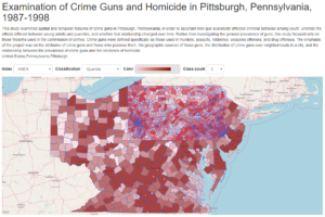
First, users can refine their searches by typing geography-related keywords. The geography search filter is controlled by a curated list of place names (3) and allows users to type a place name such as “Pittsburgh,” (4) which will return over 2,000 studies related to the city. By clicking on a study title, such as “Examination of Crime Guns and Homicide in Pittsburgh, Pennsylvania, 1987-1998” (study number 2895), users can find more details about the study, its associated data files, and descriptive metadata, as shown in Figure 1. This particular study is for public use and users can download the study data in formats that include shapefiles, Stata, SPSS, SAS, and more.
Second, the subject terms filter provides a way to narrow search results. For example, one of the studies available by filtering with the term “transportation” is the study titled “Historical Transportation of Navigable Rivers, Canals, and Railroads in the United States” (5) (study number 36353). This study contains GIS materials covering the spread of different modes of transportation in the lower 48 states from America’s founding to 1911. Geographers may be interested in the spatial patterns contained in this study that describe historical transportation networks.
Third, users can search by geography-related concepts. Searching for “land cover,” for example, returns more than 3,900 studies, as shown in Figure 2. One of the top results is the “National Neighborhood Data Archive (NaNDA): Land Use and Land Cover by Census Tract, United States, 2001-2016,” which contains measures of land cover (e.g., low-, medium-, or high-density development, forest, wetland, open water) derived from the National Land Cover Database (NLCD). These data are aggregated by U.S. census tract.
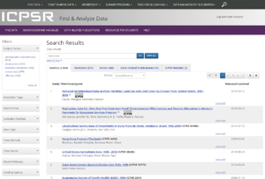
Fourth, the data type filter (on the left side of the page in Figure 2) allows users to narrow search results to GIS formats. The study titled “Exploratory Spatial Data Approach to Identify the Context of Unemployment-Crime Linkages in Virginia, 1995-2000” (study number 4546) contains ESRI shapefiles that can be used for mapping and spatial analysis.
Finally, users can narrow their search by exploring individual topical archives. The study in Figure 1, for example, is part of ICPSR’s National Archive of Criminal Justice Data (NACJD) (6). NACJD is a grouping of studies that relate to criminal justice and many associated data files contain geographic information. A list of topical archives is available on the ICPSR website.
The five methods above are good ways to refine your search for data in ICPSR’s study archive. In the results page, users can further refine their search by time period, data collection method, release date, and other filters (see filters on the left side in Figure 2).
To track the thousands of works that build on the data from ICPSR’s archive, a “Bibliography of Data-related Literature” is continuously updated. Listed works include journal articles, books, book chapters, government and agency reports, working papers, dissertations, conference papers, meeting presentations, unpublished manuscripts, magazine and newspaper articles, and audiovisual materials.
Other scholarly services at ICPSR
ICPSR provides leadership and training for the social science research community in data access, curation, and methods of research data analysis. ICPSR advances and expands social and behavioral research, acting as a global leader in data stewardship, while providing rich data resources and responsive educational opportunities for present and future generations.
In addition, ICPSR stores, curates, and provides access to scientific data so others can reuse it and validate research findings. Curation, from the Latin “to care,” is the process ICPSR uses to add value to data, maximize access, and ensure long-term data preservation. ICPSR provides guidance to members about managing their data responsibly and ethically to support transparent and reproducible research.
Since 1963, ICPSR has offered the ICPSR Summer Program as a complement to its data services, and members receive discounted tuition rates for these courses. This program provides rigorous, hands-on training in statistical techniques, research methodologies, and data analysis. Courses such as “Regression Analysis for Spatial Data” and “Spatial Econometrics” are specifically designed for spatial studies in the social sciences. The AAG is now also exploring new offerings with ICPSR to deliver courses about geographic research methods and best practices to allow scholars to leverage geospatial information in ICPSR’s collections.
References:
(1)https://www.icpsr.umich.edu/icpsrweb/membership/administration/institutions
(2)https://www.nsf.gov/awardsearch/showAward?AWD_ID=1832465&HistoricalAwards=false and https://www.nsf.gov/awardsearch/showAward?AWD_ID=1244691&HistoricalAwards=false
(3)https://www.icpsr.umich.edu/icpsrweb/ICPSR/browse/facet/studies/geographies
(4)https://www.icpsr.umich.edu/icpsrweb/ICPSR/search/studies?q=Pittsburgh
(5)https://www.icpsr.umich.edu/icpsrweb/ICPSR/studies/36353
(6)https://www.icpsr.umich.edu/icpsrweb/NACJD/discover-data.jsp